(This review of the project work to-date is an extract from the presentation at the NSPNR Annual General Meeting in October)
Why look at NSPNR’s past projects? NSPNR started in 2003 so that is over 20 years of natural resource management projects undertaken in the North Stirlings – Pallinup sub-region. One of the most informative parts of completing a project is asking what worked and what didn’t? If we don’t know about our past projects we can’t use these learnings to plan better projects.
NSPNR had a lot of project records in paper format and in digital formats, but they were stored in various places and not easily accessible or searchable. We needed a way to search those projects individually as well as examine them as a whole body of work.
The NSPNR Looking Back to Plan the Future project aims to address this and began in January 2025.
What did we do?
· Started with a partial list of projects and a list of where paper records were stored.
· Acquired the Gillamii Protocol and some help to apply it.
· Worked with volunteers to investigate the records.
· Staff have begun mapping the projects.
· 150 volunteer hours so far!
· Board members have interviewed landholders about fencing along the Pallinup River.
NSPNR started with a partial list of projects and pretty good overview of where the paper records about projects were stored in the office.
We acquired the Gillamii Protocol from the Gillamii Centre at Cranbrook. The Protocol is a system of organising records about projects and mapping the deliverables such as fencing and revegetation. Gillamii developed the protocol with Simon Neville of Ecotones in 2023-2024 in their project ‘Mapping the Way Forward’.
Freya Spencer from the Gillamii Centre and Simon Neville from Ecotones taught us to apply the protocol, particularly how to map the deliverables so we could see where fencing and revegetation and other on-ground work had been done. Going forward, the Protocol will also be used for all current and new projects.
During our ‘From Archives to Action’ volunteer days, we worked with volunteers from the NSPNR board and from the community to investigate the paper records and identify the information that we needed in order to apply the protocol.
Volunteers and staff used the information collected about past projects to create project summeries, including where more records, digital or paper, containing more details could be found. Once we had enough information about each project, staff mapped it.
Volunteers supporting the project have contributed more than 150 volunteer hours so far. At least two volunteers commented that investigating the past projects was actually fun, a bit like detective work as they tried to find the information we needed.
Board members have also been talking to landholders along the upper and middle Pallinup River about whether the land near the river is currently fenced off to exclude stock. Stock that can access the river can degrade the water quality. This survey is identifying opportunities where NSPNR can support landholders.
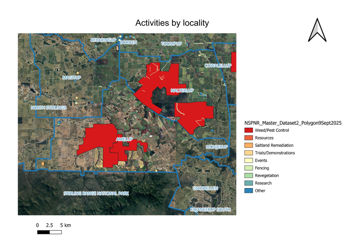
Mapping the on-ground activities is a way to visually represent the whole body of work that NSPNR has done. Figure 1 has been created by using the Gillamii protocol and just shows the Amelup section.
Figure 1: A screenshot from the QGIS app that we use to map NSPNR’s projects. It shows all the activities mapped so far in the Amelup locality and surrounds.
The map shows all the onground activities from NSPNR projects that we have mapped so far in Amelup and surrounding localities (the legend gives the colours representing the deliverables like fencing and weed and pest control). In QGIS, we can point to a feature on the map with our mouse, like a fenceline, and find out who funded the work, what project it was and who the landholder was.
To date, investigation of 41 projects has found that NSPNR has delivered:
· 355.8 km fencing
· 400.8 ha revegetation
· 4 events
· 119 ha trials
· 446 ha saltland remediation.
· 52,653 ha weed/ pest control
We still have some work to do. As noted by one of the NSPNR staff, we have done a lot more than 4 events over the years. My list of projects is still growing: there is more than 130 project codes on it.
Project highlights so far:
· Have a plan and be consistent in data creating and record keeping.
· Paper is easy. Digital degrades.
· There are some areas across the sub-region where NSPNR has not been as active.
· Consider revisiting trials such as broombush (Figure 2) and N response by tall wheat grass, and revegetation sites.
· Landholders adjoining the Pallinup River continue to want NRM activities.
· Workflow is linear but understanding is circular.
Figure 2: Investigating the records uncovered a field day that demonstrated broombush in 2007 (left). We recently contacted the landholder for a current photo of their broombush (right).
The project will continue through February next year (2026). We still have a number of projects to investigate and add to the map for a more complete visual representation of NSPNR’s work. At the end of the project a final report including recommendations for future NRM activities will be prepared for the NSPNR board and staff.
This project is supported by funding from the Western Australian Government’s State NRM Program.